The roads and highways humans have built bisect the natural environment and divide the ranges and migratory routes of many species, presenting a danger to the animals who need to cross them.
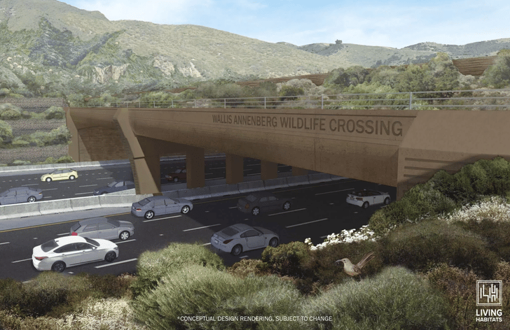
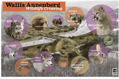
This month, the world’s largest wildlife overpass — the Wallis Annenberg Wildlife Crossing — will begin construction across a multi-lane highway at Liberty Canyon in the Santa Monica mountains. The 210-foot long, 165-foot wide green bridge will allow animals like mountain lions, coyotes, snakes and toads to safely cross U.S. Highway 101 near Los Angeles, reported The Guardian. It will be surrounded by an acre of native plants, and sound walls covered with vegetation will be put in place to help shield nocturnal animals from noise and light.
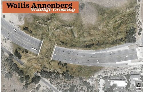
According to the Santa Monica Mountains Conservancy, the division of the Simi Hills and Santa Susana Mountains from the Santa Monica Mountains by Highway 101 resulted in fragmented habitats and restricted movement for native species, which interfered with breeding and hunting, especially for larger mammals like bobcats and mountain lions.
“The freeway is a formidable and virtually impenetrable barrier for many wildlife species including mountain lions, bobcats, gray foxes, coyotes, and mule deer that inhabit and travel between these two mountain ranges,” the Santa Monica Mountains Conservancy said in a press release. “For mountain lions in particular, the consequences of this restriction results in increased inbreeding and territorial fighting, and very low genetic diversity, within the Santa Monica Mountains.”
Mountain lions are a “specially protected species,” according to the California Department of Fish and Wildlife. Since 2002, at least 25 mountain lions have been killed on freeways in Los Angeles, The Guardian reported. And on March 23, a young mountain lion was killed on the Pacific Coast Highway.
The groundbreaking ceremony for the Wallis Annenberg Wildlife Crossing will coincide with Earth Day on April 22, and the bridge is expected to be completed in early 2025. About 60 percent of the funding for the approximately $90 million wildlife crossing came from private donations.
“Someone could be in rush-hour traffic, and there could be a mountain lion right above them,” said project planner and urban ecologist with the National Wildlife Federation Beth Pratt, according to The Guardian. “I think that’s such a hopeful image, and one that inspires me that we can right some of these great wrongs.”
A well-known mountain lion called P-22 who lives in Griffith Park in the Loz Feliz neighborhood of Los Angeles and criss-crosses freeways to roam his habitat has come to represent the plight of the many wild animals who have had their homes destroyed and divided by human development.
“People really took his plight to heart, and this is not just a California story: the world has come together around his cause,” Pratt said, as The Guardian reported.
Unfortunately, P-22 isn’t likely to be one of the mountain lions in the area who uses the bridge, since his range lies farther east.
It could take as long as five years for some animals to grow accustomed to using the crossing.
Canada’s Banff National Park is an example of the success of wildlife crossings. With more than three dozen overpasses and underpasses for animals, the park has seen a 90 percent decrease in accidents between vehicles and wildlife.
Hopefully there will be many more in the future, as communities come together to try and help humans and wildlife live together more safely and peacefully. The Biden administration’s infrastructure bill has $350 million set aside for things like underpasses, overpasses and fences to help wildlife.
“As both a tool for and a symbol of connection, [the Wallis Annenberg Wildlife Crossing] will stand as an alluring challenge to future generations to pick up the mantle of design to bridge the gaps elsewhere in our world,” said design leader and landscape architect with Chicago’s Living Habitats Robert Rock, as reported by The Guardian.
More from MediaFeed:
- The surprising last words of some of the world’s most famous people
- These are the richest TV & movie stars of all time
- 13 bizarre inventions that never took off
- The most crime-ridden cities in the US
Like MediaFeed’s content? Be sure to follow us.
This article originally appeared on Ecowatch.com and was syndicated by MediaFeed.org.
States with the deadliest roads in America

Roughly 36,000 people die on American roads each year.
With that in mind, which states are home to the most deadly roads in America?
While you might think that huge interstates top the list for most dangerous roads, it’s smaller roads that are the most deadly, based on the number of fatal accidents per 100 miles.
Related: Surrounded by rude drivers? You probably live in this state
DepositPhotos.com

To determine the most dangerous roads, we used Fatality Analysis Reporting System data from the National Traffic and Highway Safety Administration. We looked at their “Accident” data file for 2019 in order to determine the number of accidents that occurred on each road. We also took the length of each road in order to calculate the number of fatal accidents per 100 miles. In order to determine which roads were the most dangerous, we looked at roads with at least ten fatal accidents and ranked by the number of fatal accidents per 100 miles.
We used the same data to similarly determine the number of fatal accidents per 100 miles that happened by the type of road — State route, U.S. highway, non-three-digit Interstate and three-digit Interstate.
To determine the most dangerous roads in bad weather, we looked at roads with at least ten fatal accidents that occurred in rain, sleet/hail, snow, fog/smog/smoke, blowing snow, or freezing rain/drizzle.
Here are the 30 most dangerous roads in America…
katleho Seisa/istockphoto
")
Length of road: 50 miles
Number of fatal accidents per 100 miles: 22
Wikipedia.org
")
Length of road: 92 miles
Number of fatal accidents per 100 miles: 23
Wikipedia.org
")
Length of road: 46 miles
Number of fatal accidents per 100 miles: 24
Google Maps
")
Length of road: 161 miles
Number of fatal accidents per 100 miles: 25
Google Maps
")
Length of road: 75 miles
Number of fatal accidents per 100 miles: 27
Google Maps
")
Length of road: 132 miles
Number of fatal accidents per 100 miles: 27
Google Maps
")
Length of road: 55 miles
Number of fatal accidents per 100 miles: 29
Google Maps
")
Length of road: 32 miles
Number of fatal accidents per 100 miles: 31
Google Maps
")
Length of road: 50 miles
Number of fatal accidents per 100 miles: 32
Google Maps
")
Length of road: 49 miles
Number of fatal accidents per 100 miles: 33
Google Maps
")
Length of road: 30 miles
Number of fatal accidents per 100 miles: 34
Google Maps
")
Length of road: 61 miles
Number of fatal accidents per 100 miles: 36
Google Maps
")
Length of road: 27 miles
Number of fatal accidents per 100 miles: 37
Google Maps
")
Length of road: 27 miles
Number of fatal accidents per 100 miles: 37
Google Maps
")
Length of road: 55 miles
Number of fatal accidents per 100 miles: 38
Google Maps
")
Length of road: 61 miles
Number of fatal accidents per 100 miles: 39
Google Maps
")
Length of road: 30miles
Number of fatal accidents per 100 miles: 40
Google Maps
")
Length of road: 64 miles
Number of fatal accidents per 100 miles: 41
Google Maps
")
Length of road: 26 miles
Number of fatal accidents per 100 miles: 42
Google Maps
")
Length of road: 50 miles
Number of fatal accidents per 100 miles: 42
Google Maps
")
Length of road: 28 miles
Number of fatal accidents per 100 miles: 43
Google Maps
")
Length of road: 59 miles
Number of fatal accidents per 100 miles: 51
Google Maps
")
Length of road: 26 miles
Number of fatal accidents per 100 miles: 51
Wikipedia.org
")
Length of road: 23 miles
Number of fatal accidents per 100 miles: 57
Google Maps

Length of road: 120 miles
Number of fatal accidents per 100 miles: 62
Google Maps
")
Length of road: 16 miles
Number of fatal accidents per 100 miles: 64
Google Maps
")
Length of road: 23 miles
Number of fatal accidents per 100 miles: 65
Google Maps
")
Length of road: 19 miles
Number of fatal accidents per 100 miles: 77
Google Maps
")
Length of road: 14 miles
Number of fatal accidents per 100 miles: 95
Google Maps
")
Length of road: 20 miles
Number of fatal accidents per 100 miles: 112
This article originally appeared on Finder.com and was syndicated by MediaFeed.org.
Google Maps

jacoblund / istockphoto
Featured Image Credit: Living Habitats and National Wildlife Federation.